Experience our advanced flood prediction
technology for urban resilience.

Empowering officials to protect vulnerable populations
with real-time, high-density rainfall data.

Urban Floods

Urban floods occur when heavy rainfall exceeds the capacity of a city's drainage system.

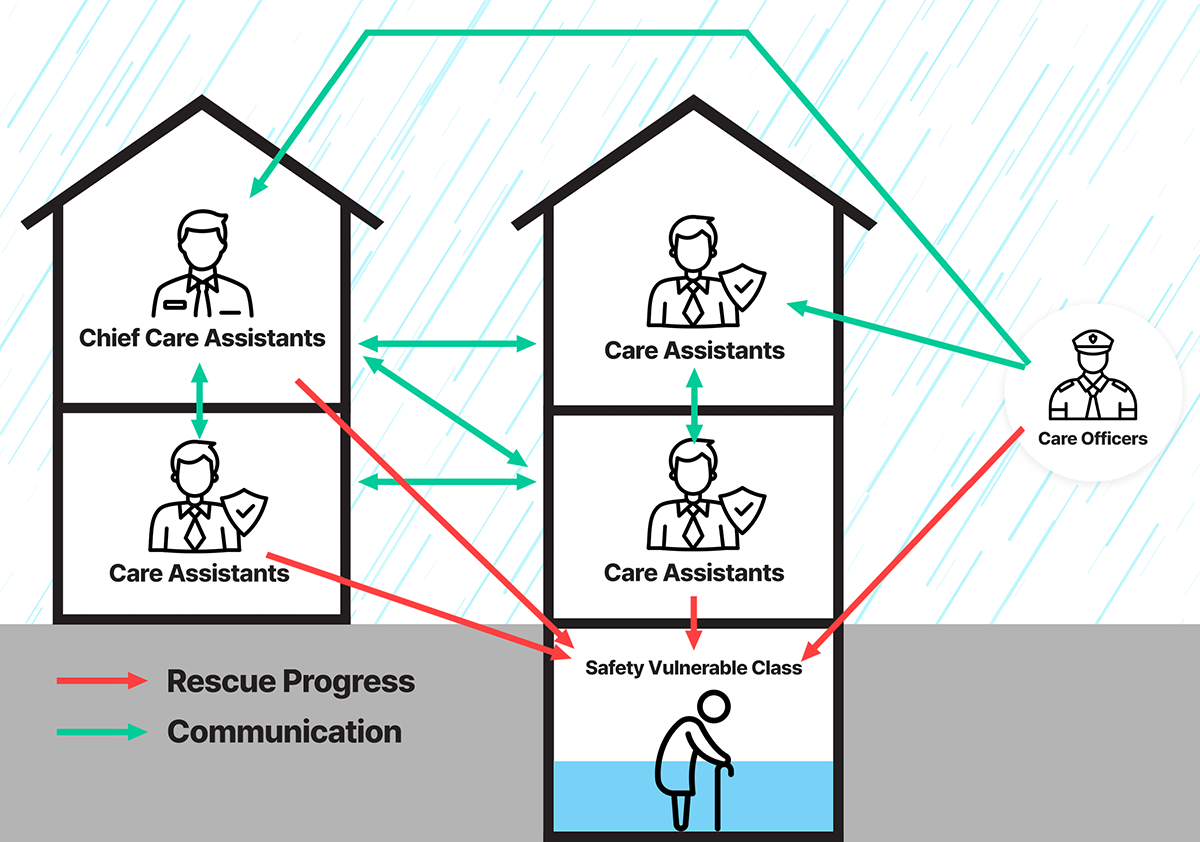
Large amounts of rain that exceed drainage capacity due to localized heavy rainfall make these floods difficult to manage and cause serious damage to both the natural and built urban environments, which are especially vulnerable to disaster-vulnerable groups such as the elderly and the disabled.

EXCEEDS CAPACITY
Experience our advanced flood prediction technology for urban resilience - empowering officials to protect vulnerable populations with real-time, high-density rainfall data.
Safety Vulnerable Class

    Introduction

  • Safety Vunerable Class include those who may face difficulties in moving or evacuating during natural disasters such as floods. This group encompasses the elderly, individuals with disabilities, young children, and those with chronic illnesses.
  • Role

  • Receive Real-Time Alerts: Get warnings and evacuation instructions for rainfall and flood risks.
  • Share Location Information: Provide their location (opt-in) to enable Care Officers and Companion Partners to reach them quickly.
  • Communicate Needs: Request additional assistance when necessary through the system.
Care Officers

    Introduction

  • Care Officers are local government officials responsible for ensuring the safety of vulnerable individuals during disasters.
  • Role

  • Monitor Hazard Situations: Utilize high-density rainfall data to identify flood-prone areas.
  • Plan and Execute Evacuations: Design evacuation routes and allocate resources to assist vulnerable individuals.
  • Real-Time Communication: Coordinate with vulnerable individuals and Companion Partners to manage evacuation efforts effectively.
Care Assistants

    Introduction

  • Care Assistants work alongside Care Officers to provide direct support to vulnerable individuals during evacuations. They can include volunteers, NGO members, or community representatives.
  • Role

  • On-Site Evacuation Assistance: Accompany vulnerable individuals to ensure safe evacuation.
  • Report Situational Issues: Notify Care Officers of any problems encountered during evacuation.
  • Deliver Support Supplies: Provide necessary items to vulnerable individuals on their way to shelters.
Disaster Alert Process
01After device installation
  • Meteorological Administration standard measuring instrument (type approved)
  • Device maintenance and operation management
  • Algorithm forecast (within 3 hours)
02Flood forecast issuance criteria
  • ① Rainfall per hour When exceeding 55mm
  • ② Rainfall per 15 minutes When exceeding 20mm
  • ③ Flood depth exceeds 15cm based on road water level gauge
03Flooding forecast dissemination & action
  • Community center
  • District Office Dentistry Department
  • City Hall Dentistry Department
  • Other government offices
Operating Process
Our Goals
Public observation networks

Current public observation network resolution (12km unit)

Our Solutions

Observation network resolution that can be provided by us(1km unit)

Provides customized weather data specific to the installation area compared to existing public low-resolution data.
Our Solutions
Product Introduction
  • The smart rain gauge accurately measures rainfall in real time, enabling rapid response to weather changes
  • It responds sensitively to changes in the external environment and provides rainfall data in 1-minute unit
  • It can be installed and operated anywhere using wireless communication functions and solar power, and maintenance is also minimized, enabling efficient management
Application Areas
  • Disaster Management: Predict and respond to risks through real-time monitoring in areas at risk of flooding and inundation
  • Urban Management: Used as a smart city's meteorological infrastructure, linked to road, traffic, and sewage management systems
  • Agriculture: Provides accurate rainfall data required for crop management and water resource management
  • Environmental Protection: Contributes to water resource management and environmental protection projects through rainfall data
Technical Specifications (Design Characteristics)
  • WMO (World Meteorological Organization) standards
  • Measurement Unit: Rainfall can be measured in 0.1mm units
  • Communication Method: Supports LTE, 5G, and LoRa wireless communication
  • Power Supply: Solar panel and battery
  • Data Storage: Cloud server linkage and remote Management
Product Specifications
  • Size: 50cm x 50cm x 100cm
  • Weight: 45kg
  • Material: Durable plastic and aluminum alloy
  • Durability: Waterproof and dustproof (IP67 certified)
Product Performance
  • Maximum allowable error rate: RG: ±0.1mm / WD: ±5° / WS: ±0.5m/s
  • Resolution: RG: 0.1 / WD: ±5° / WS: ±0.5 m/s
  • Stability: Normal data rate 80% or higher
  • Power supply method: Solar panel 60W, AC/DC 12V
Importance of Rain Gauge Installation Locations
  • Proper installation of rain gauges is critical for accurate and reliable rainfall measurement. Here are the key reasons why the selection of installation sites is so important:
1. Data Accuracy and Reliability
  • Minimizing Measurement Errors : Rain gauges must be installed in locations free from obstructions such as trees, buildings, or other structures that can block or divert rainfall, leading to inaccurate readings.
  • Avoiding Wind Effects: Wind can influence the trajectory of rainfall, reducing the amount of rain captured by the gauge. Installation in areas with minimal wind interference ensures more precise data.
2. High-Density Observation Network
  • Localized Data Collection: Installing rain gauges at multiple locations ensures comprehensive data coverage. This is especially important in urban areas where rainfall distribution can vary significantly within short distances.
  • Real-Time Monitoring: A dense network of rain gauges enables minute-by-minute monitoring, providing early warning for areas at risk of flooding.
3. Flood Prediction and Risk Management
  • Improved Flood Forecasting: Accurate rainfall data from well-placed rain gauges is essential for predictive models to forecast potential flood events.
  • Efficient Evacuation Planning: Timely and precise data helps public officials take preventive actions, such as evacuating vulnerable populations before flooding occurs.
4. Supporting Urban Drainage Systems
  • Identifying Drainage System Limitations: Data from strategically placed rain gauges can help identify areas where the drainage system is likely to fail under heavy rainfall.
  • Preventing Urban Flooding: Early detection of rainfall patterns allows city planners to improve drainage infrastructure and implement proactive measures.
5. Environmental and Economic Impact
  • Protecting Natural Resources: Accurate rainfall measurements contribute to sustainable water resource management.
  • Reducing Economic Losses: Timely flood prevention measures based on reliable data can save cities from significant financial damage caused by property destruction and infrastructure failures.
Why WMO standard weather monitoring
instruments should be used
Data Accuracy and Consistency
High Accuracy and Standardization
  • WMO-standard instruments are designed to meet rigorous international standards, ensuring high accuracy and consistency in weather data.
  • Low-cost or small instruments, while affordable, often lack the precision and reliability required for accurate meteorological measurements, especially in critical applications like flood prediction and climate research.
Global Data Compatibility
  • Standardized instruments provide data in a globally recognized format, ensuring compatibility with other national and international systems.
  • This ensures that the data can be shared and integrated seamlessly across countries and regions for global climate studies, weather forecasting, and disaster management.
  • Low-cost or small instruments may use proprietary formats or lack calibration consistency, making it difficult to compare data internationally or to integrate it into larger networks.
International Collaboration and Data Sharing
WMO Data Sharing Agreements
  • Under the WMO agreements, countries share meteorological data that is standardized and reliable, supporting global weather forecasting and disaster response.
  • WMO standard instruments are essential for ensuring that the data exchanged meets the necessary standards for international collaboration.
  • Low-cost instruments may not be acceptable in the WMO data-sharing network due to inconsistent data quality, limiting the potential for cross-border cooperation.
Reliable and Accurate Forecasting
  • Standard instruments provide data that can be used for high-precision weather forecasts.
  • For example, accurate rainfall data from WMO-standard rain gauges is crucial for flood forecasting systems, which can predict flooding more accurately and issue timely warnings.
  • Low-cost or small instruments may have calibration errors or limitations in data range, reducing their usefulness in creating accurate weather forecasts or flood warnings.
Disaster Response and Public Safety
Flood Prediction and Early Warning
  • High-quality, standardized instruments are essential in disaster prevention and early warning systems, particularly for flooding events.
  • WMO-standard rain gauges can detect heavy rainfall and flooding conditions at a high level of precision, triggering automated alerts for authorities to act.
  • Low-cost instruments often lack the sensitivity and durability needed to reliably detect extreme weather conditions, thus delaying or hindering early warning systems.
Consistent Monitoring for Emergency Management
  • Standard instruments provide consistent, long-term monitoring, which is essential for tracking long-term trends in weather and climate data. This helps emergency services and government agencies to anticipate weather-related disasters and prepare accordingly.
  • Low-cost or small instruments may break down more often or provide inconsistent data over time, undermining disaster preparedness efforts.
Long-Term Cost Efficiency and Durability
Reduced Maintenance and Replacement Costs
  • WMO-standard instruments are built to last and require less frequent maintenance or replacement. They offer long-term durability and reliability, reducing overall costs over the life cycle of the equipment.
  • Low-cost instruments, on the other hand, are more likely to need frequent repairs or replacements due to their lower build quality. This can end up being more expensive in the long run, especially when maintenance costs are factored in.
Investment in Reliable Infrastructure
  • Using standard instruments contributes to creating a reliable infrastructure for weather observation networks, making them more capable of supporting long-term public safety efforts, policy development, and environmental monitoring.
  • Low-cost equipment often does not offer the same level of investment in research, development, and manufacturing standards, meaning it may fail to meet the long-term needs of weather monitoring and flood prediction systems.
Supporting Climate Change Research and Policy
Essential for Climate Research
  • Accurate and high-quality data is essential for tracking and understanding climate change. Standard instruments are required to measure critical environmental factors such as temperature, rainfall, and wind speed in a consistent and accurate manner.
  • Low-cost instruments may lack the precision needed for the data required in climate models, which can lead to errors or inaccuracies in climate change research and policy recommendations.
Policy and Decision-Making
  • Governments and policymakers rely on accurate weather data to make decisions related to disaster management, environmental protection, and infrastructure development.
  • WMO-standard instruments provide the kind of reliable data needed to inform these decisions, ensuring that they are based on accurate, consistent information.
  • Low-cost instruments may fail to provide the necessary data quality for reliable decision-making, potentially leading to poor policy outcomes.
Reason why it should not be
installed and operated anywhere
Ensuring Data Accuracy and Reliability
Importance of Observational Environment
  • WMO standard meteorological instruments are designed to provide accurate and reliable weather data, which requires adherence to specific installation environment conditions.
  • External factors such as nearby buildings, trees, or terrain can interfere with measurements of wind, rainfall, or temperature, compromising data accuracy.
Compliance with International Standards
  • The WMO Guide to Meteorological Instruments and Methods of Observation outlines strict guidelines for observation environments to ensure consistent and comparable data.
  • Failure to adhere to these guidelines can result in data being considered unreliable or invalid in international meteorological networks.
Risk of Data Distortion
Interference from Local Environmental Factors
  • Installing instruments in inappropriate locations such as urban areas, mountainous regions, or industrial zones can introduce distortions due to local influences like urban heat islands, air pollution, or abnormal wind patterns.
  • Such distorted data can negatively affect national weather forecasting systems and climate research.
Errors from Non-Standard Installation
  • If instruments are installed at non-standard heights, incorrect orientations, or irregular terrains, measurements of pressure, wind speed, or rainfall can be inaccurate.
  • These errors can lead to faulty weather predictions and misguided decision-making.
Challenges in International Data Integration
Global Data Compatibility Issues
  • Instruments improperly installed in unsuitable locations may produce data incompatible with global meteorological databases.
  • This can hinder climate change studies, weather forecasting, and disaster management efforts that rely on global data sharing.
Reduced Accuracy in Forecast Models
  • Poor-quality data can reduce the accuracy of forecast models, undermining the reliability of early warning systems.
  • For example, inaccurate rainfall data may result in missed flood warnings or false alarms.
Safety and Maintenance Concerns
Physical Damage to Instruments
  • Instruments installed in unsuitable locations are more vulnerable to damage from extreme weather conditions such as storms, heavy rainfall, or strong winds.
  • This not only disrupts data collection but also increases maintenance and replacement costs.
Accessibility Issues
  • Instruments installed in remote or inaccessible locations may make regular inspections and maintenance difficult.
  • This can compromise the longevity and reliability of the equipment.
Reduced Data Usability and Cost-Effectiveness
Inefficient Use of Data
  • Data collected from inappropriate locations often has limited usability in climate analysis and disaster management.
  • This represents a waste of resources and investment in the equipment.
Lower Return on Investment
  • WMO standard instruments are expensive, high-precision devices. Improper installation undermines their effectiveness, reducing the return on investment.
Adherence to WMO Recommendations
WMO provides clear guidelines for the placement and operation of meteorological instruments. Non-compliance can result in:
  • 1. Loss of credibility in international collaboration.
  • 2. Degradation of the quality and reliability of national and regional forecasts.
  • 3. Rendering the operation and investment in the instruments ineffective.
Disaster Alert Process in Seoul
01Data Monitoring
  • ① Rainfall threshold: 55mm per hour
  • ② 15-minute rainfall: 20mm
  • ③ Road water level flooding depth: 15cm
02Flood Forecast Issuance
  • Issuance Method Issued if rainfall or flooding depth exceeds threshold.
  • Issuing Authority Seoul Disaster Safety Headquarters
  • Recipients Districts, police, fire department, community partners, etc.
03Flood Warning Issuance
  • Issuance Method Issued based on flooding conditions and risk assessment.
  • Issuing Authority District Disaster Safety Headquarters
  • Recipients General public (via disaster messages, warning broadcasts, etc.)
Number of Safety Vulnerable Classes
  • 954 households (Residents in semi-basement housing, including individuals with severe disabilities, the elderly, and children)
Personnel Composition
  • Total: 2,391 people (approximately 5 people per household, including nearby residents, local leaders, and public care officials) * Nearby Residents: Residents living in the same building as the target household or within a 5-minute walking distance.
Primary Duties
  • Visit vulnerable households during flood forecasts and provide swift evacuation assistance during warnings
Communication System
  • A group chat room on KakaoTalk, managed by public care officials

In operation, the FloodWatch monitoring system

can support city management by :
01

Support and establish an automated evacuation system to help Care officials make appropriate evacuation decisions for citizens before and after a flood.

02

Improving the convenience of evacuation for Safety Vulnerable Class. (e.g. flood warning)

03

Improved evacuation efficiency of accompanying Care partners.

TOOLS
APP

Early warning service and automated evacuation assistance solution

Smart Rain Gauge

Smart Rain Gauge

Modeling

Modeling Flood prediction

SERVICE
Early Warning Service

for citizens

Our WMO-standard rain gauges deployed at a density 13 to 20 times higher than traditional weather observation networks, capturing precise rainfall data every minute. Our real-time flood prediction and alert system empowers public care officials to efficiently assist vulnerable populations in evacuating during flood emergencies. By utilizing high-density observational data, our automated solution delivers accurate and timely flood risk analyses, minimizing potential casualties and setting a new standard for disaster response.

Our WMO-standard rain gauges deployed at a density 13 to 20 times higher than traditional weather observation networks, capturing precise rainfall data every minute. Our real-time flood prediction and alert system empowers public care officials to efficiently assist vulnerable populations in evacuating during flood emergencies. By utilizing high-density observational data, our automated solution delivers accurate and timely flood risk analyses, minimizing potential casualties and setting a new standard for disaster response.